Citizen science weed mapping
to improve weed management and protect biodiversity
Nature Conservation Margaret River Region has launched a new mobile phone app called “Fieldbook” that enables our community to collect valuable data to better manage weeds in our region.
Everyone is urged to download the free Fieldbook app, which allows people to record target invasive weed species they see in any area of bushland, national park, road verge or reserve in the region. More than 13 weed species can be reported, including arum lilies and high-priority, non-native woody weed trees that are a major conservation concern across the Margaret River region.
The Fieldbook app was made possible thanks to funding from State Natural Resource Management Programs WA, with generous assistance and development of the app by Fieldwork Labs.
How to install and use the app
SIGN UP for Fieldbook. Or VIEW OUR HANDY HOW-TO GUIDE or see the adjacent graphic for detailed and easy-to-understand instructions to install the app.


Help us collect valuable data
Weed mapping is also important to identify the presence and extent of weed infestations, and zero in on threats to high priority areas. The information collated by Nature Conservation will be shared with community groups and government departments and will be used to prioritise control and measure change over time.
“We’re really excited. The Fieldbook app will enable us to get weed mapping data across the whole region that will lead to good decision making and priority setting, and assist with long term monitoring,” says Nature Conservation’s biodiversity officer Peta Lierich. “An easily accessible app being used by many people will also enable means rapid detection of invasive species infestations when they’re small and can be more easily tackled.”
Mapping arum lilies
As arum lily is such a widespread issue in the region, we are encouraging everyone to help us collect data that reveals information about its presence and the pattern of spread. This will help us make strategic decisions about where to direct resources.
We would like to collect data across all public land including the national parks, roadsides and reserves. When using the app to map arum lilies, don’t forget to:
- First determine the area or track you will be mapping.
- Submit many weed records for the area you are mapping. The more data the better as this enables us to get a clearer picture of the presence, extent and density of infestations.
- Recording an observation at 10m intervals is recommended, paying particular attention to density. Note that it is still important to record ‘Absent’ or ‘Individual plant’ at given intervals, particularly to show the edge of an infestation as this helps reveal a pattern of spread.
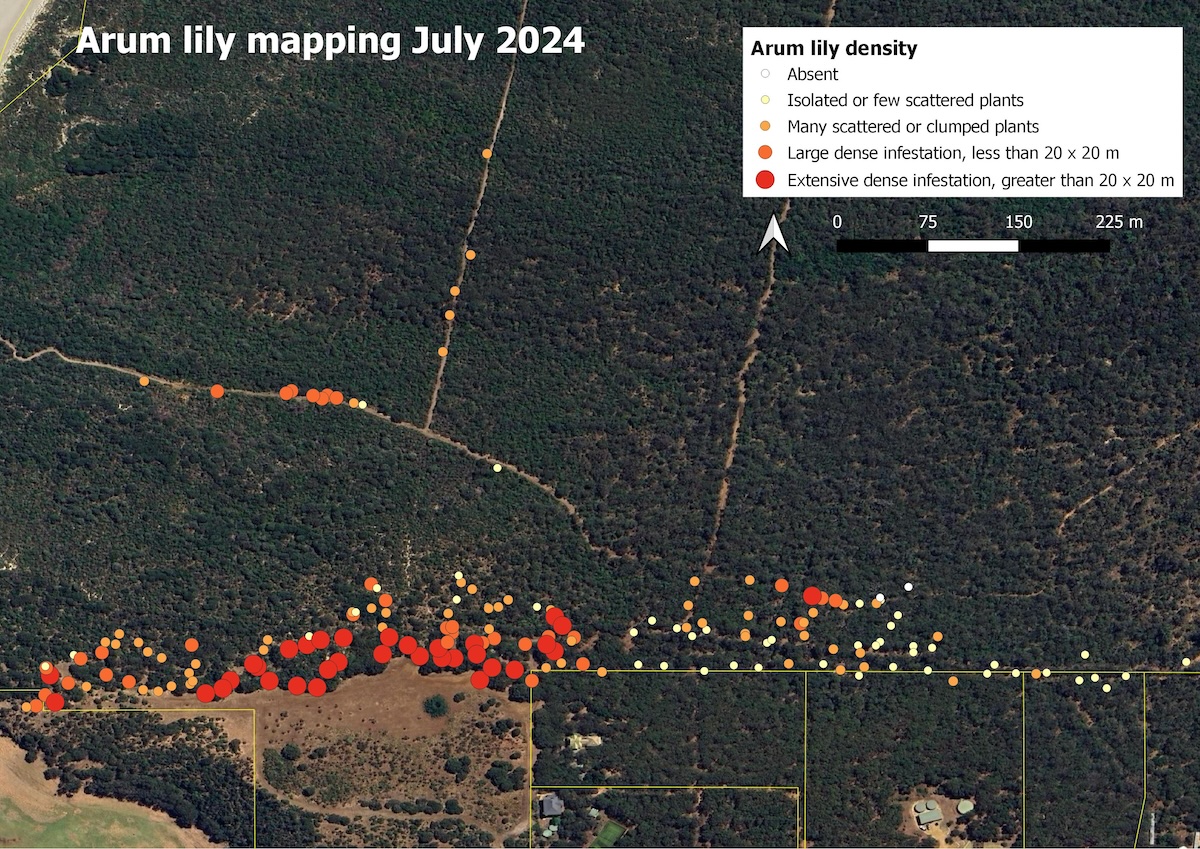
SEE AN EXAMPLE OF OUR ARUM LILY MAPPING USING FIELDBOOK DATA
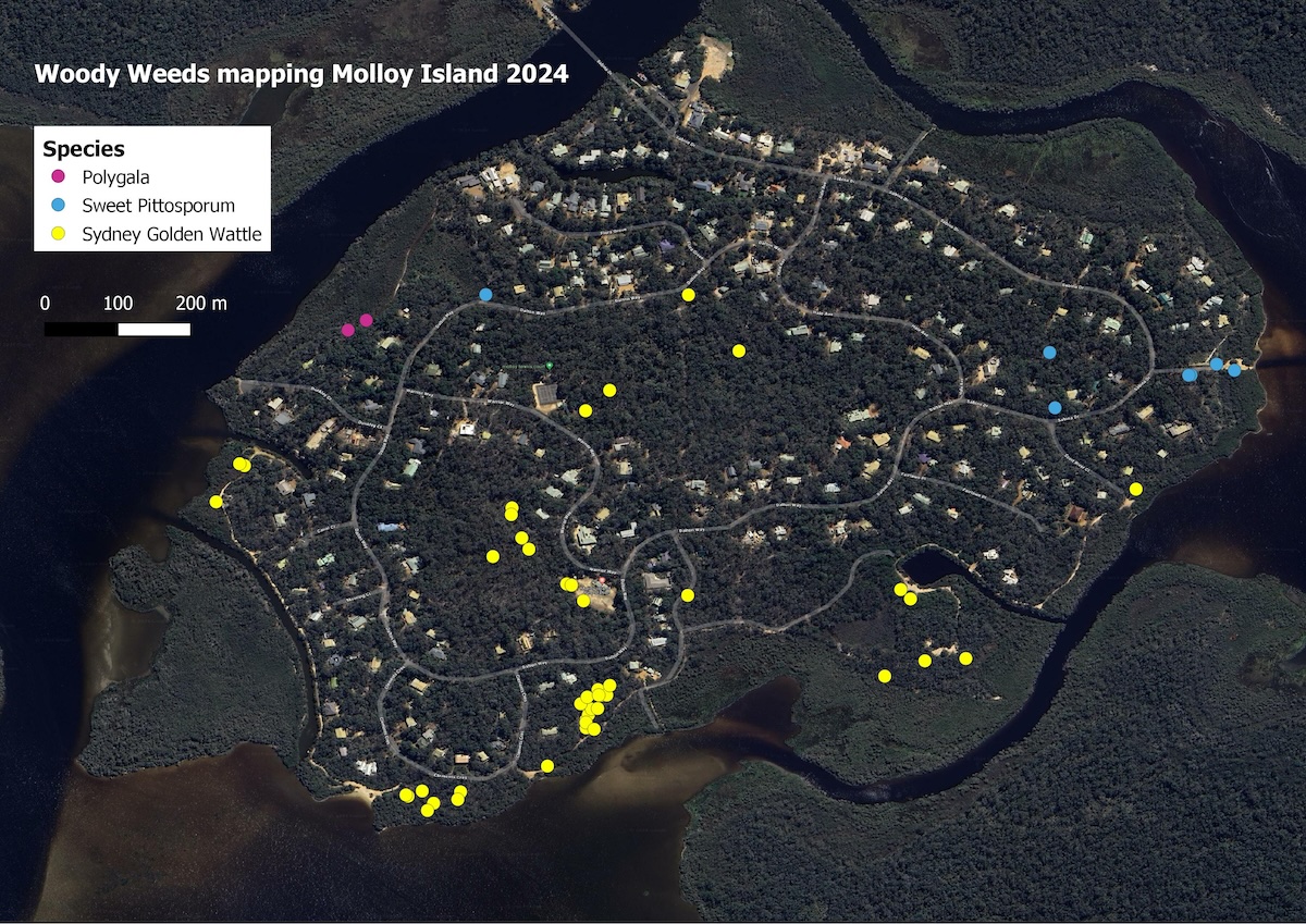
Mapping woody weeds
For woody weeds, we are interested in presence and absence data as well as density change over an area. For this reason, single sighting data is more useful for mapping woody weeds than species such as arum lily.
When using the app to map woody weeds. Consider the following key points:
- We encourage you to submit opportunistic sighting data of woody weeds whenever you are out and about in bushland areas.
- The ‘size’ parameter is more relevant to woody weeds than arum lily as it tells us valuable information relating to management (e.g. a mature plant is more likely to set fruit/seed).
Troubleshooting and FAQS
Issues with location permission
As the app is a web-based app (unlike local apps you might download from the App Store), the location must be enabled in your browser settings. For most, the default browser settings should mean the location is enabled out of the box, however it is possible that your settings have been modified at some point.
- To do this using Android: Open Chrome app (or your default browser) > Click on menu > Settings > Site Settings > Location > Find https://ncmrr.fieldbook.xyz in the list > Select Allow
- To do this using iOS (iPhone): Go to Settings > Privacy & Security > Location Services > Safari Websites > Select ‘While using the app’. There are additional location settings in iOS so you may also need to: Go to Settings > Safari > Location > Tick ‘Ask’
Does the app work whilst I am out of range?
Yes – once installed locally on your device the app will work offline via satellites. However, you will need reception to export the data. It is important to install the app and not use the browser-based application when in the field.
Can I go back and edit an entry?
Yes – it is possible to edit entries by clicking to the right of the record, then clicking on the pencil icon. You can edit data and resubmit up until the point that you have cleared all data.
Latest news on Weed Mapping
From Coffee to Conservation: Landholder Fights Arum Lily
Local landholder, conservation volunteer and Five Senses Coffee founder Dean Gallagher is helping lead the fight against invasive arum lilies in one of the South West’s most precious landscapes. Dean and his family live on 50 acres of thriving native forest at...
Orchids and wildflowers return after Blitz on arum lily
Nature Conservation Margaret River Region is celebrating another powerful local success story from its Arum Lily Blitz, with local landholder, complimentary therapist and nurse Sarah Moore seeing the return of abundant native wildflowers and orchids after several...

Arum Lily Blitz takes centre stage internationally
Nature Conservation Margaret River Region’s community-powered Arum Lily Blitz is set to be showcased on the international stage this year, as the innovative WA program continues to grow in scale, impact and ambition. The Arum Lily Blitz model will be presented at the...
Address
Community Resource Centre
33 Tunbridge Street
Margaret River WA 6285
Postal Address
PO Box 1749 Margaret River WA. 6285
Contact Us
Phone: (08) 9757 2202
Email: info@natureconservation.org.au